


Using 3D seismic data, scientists have traced how the depositional history of sediments in a basin can be deciphered by using 3D seismic data, which in turn, can pave the way for the exploration of hydrocarbons and provide insights to geo- or seismo-tectonics of the area.
The Upper Assam basin in NE India is surrounded by the Himalayan mountain belt in the north, Naga Hills in the south, and Mishmi Hills in the east. Most of the sediments belong to the Tertiary period (66 - 2.5 million years ago ) and recent alluvium cover. Seismic data can play an important role in unraveling the depositional environment of these sediments in basin.
Dr. Kalachand Sain, Director, Wadia Institute of Himalayan Geology (WIHG), an autonomous institute under the Department of Science & Technology (DST), Govt. of India, along with Dr. Priyadarshi Chinmoy Kumar, scientist at WIHG explored the textural responses from high-resolution 3D seismic data within the Dibrugarh field in Upper Assam basin to untangled the depositional environment of the sedimentary succession.
The study shows that the textural characteristics of the Oligocene Barail coal-shale unit (deposited between 33.9 to 20.4 million years ago ) is associated with the deformed, wavy, chaotic, and heterogeneous texture indicating a deeper basinal condition prevailing during its deposition (as shown in the maps ). Whereas the overlying Miocene Tipam sandstone unit (deposited between 20.4 to 11.6 million years ago ) is associated with less chaotic and high homogeneity textures (molassic type), indicating a fluvial environment during its deposition (as shown in the maps).
This research was carried out by Seismic Interpretation Laboratory (SIL), established at WIHG, Dehradun, and is published in the journal of Geological Society of India. Such study is useful not only for the exploration of hydrocarbons in the thrust-fold belt but can also provide insightful implications to the geo- or seismo-tectonics of an area on a finer scale.
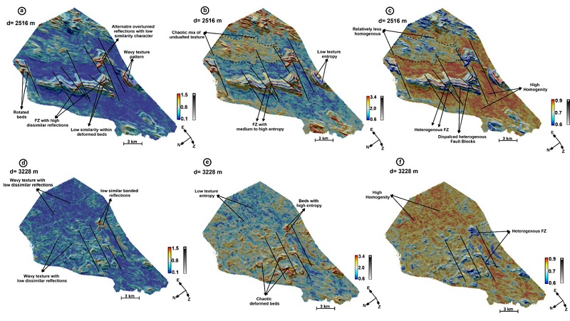
Fig. 1: Depth slices at 2516 m (a-c) and 3228 m (d-f), displayed with different attributes: Texture-Dissimilarity (a & d); Texture-Entropy (b & e), Texture-Homogeneity (c & f), co-rendered with relief attribute reveal varied textural characteristics such as wavy, chaotic, dissimilar and homogeneity prevailing within the Oligocene-Miocene intervals. Thick black lines mark faults. Note that a pastel colour scale is used represent the Texture attributes, whereas grey colour scale is used to represent the relief attribute.
Publication link: https://doi.org/10.1007/s12594-022-2236-2
")


")


