Frequency of extreme rainfall is likely to increase over the Western Ghats and Northeast river basins, while an increase in heavy rainfall intensity is projected over the Upper Ganga and Indus basins. The study explored the new possible hotspot regions for future urban flooding due to increasing heavy rainfall patterns over different Indian River Basins.
In the past few decades, the increased frequency of hydroclimate extreme events over the Indian River basins (IRBs) due to global warming has led to a significant rise in flood-related disasters, mortality rates, and economic losses, ultimately affecting the gross domestic product. In this context, it becomes exceedingly essential to examine the future hydroclimate extremes and identify hotspot regions over the Indian River Basins (IRBs) that are most susceptible to hydroclimate extremes. This can enable the prioritization of urgent policy interventions, mitigation and adaptation strategies.
A research led by Prof. R. K. Mall, Cordinator of the Department of Science & Technology-Mahamana Centre of Excellence in Climate Change Research (DST-MCECCR) at Banaras Hindu University (BHU), including Ph.D. scholar Pawan Kumar Chaubey, used high-resolution simulated precipitation from Coupled Model Intercomparison Project-6 (CMIP6) experiments to examine the future hydroclimate extremes over the different River Basins of India. The work supported under the Climate Change Program of the Department of Science & Technology (DST), projected intense precipitation specially over the Western Ghats and Northeast river basins, and an increase in heavy rainfall intensity (14.3%) over the upper Ganga and Indus basins as well as intensification of severe droughts.
The study highlighting an agricultural drought in the lower Ganga basin due to a decline in mean rainfall was published in the renowned journal Earth’s Future, American Geophysical Union (AGU). It urged policymakers to devise strategies to cope with water surplus or scarcity.
The research elaborated that approximately 4% to 10% of the heavy rainfall is projected to increase over the western part of Indian River basins. In the mid-future, under certain carbon emission scenarios, a significant increasing change of about 30% precipitation per day was likely over the West flowing River Kutch & Saurashtra, including Luni, Indus, and Upper Ganga River Basins.
The results also showed that the significant changes in the frequency of hydro-climate extreme events may have a considerable impact on agriculture, health, and other socio-economic conditions of the society. The major hotspots of highly populated cities identified for future urban flooding could help policymakers design appropriate basin-wise climate adaptation and mitigation strategies, including water and emergency services policies to minimize risk due to extremes in the basins.
Publication Link: https://doi.org/10.1029/2023EF003556 ( Earth's Future, AGU )
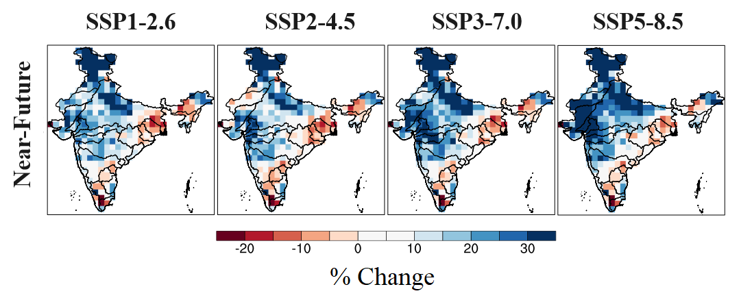
Fig. 1 Increasing and decreasing trend of annual mean precipitation change (%) from low to high emission scenarios for Near-future (2021–2040) relative to 1995–2014.
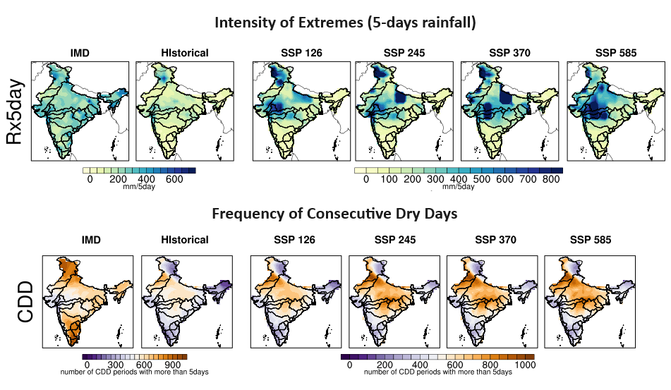
Fig. 2 Spatial changes in observed and projected intensity of extreme precipitation events (5-day rainfall) and frequency of extreme events (dry days).


