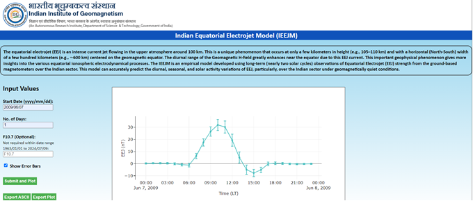
Scientists tracking a very narrow band of intense electric current in the earth’s ionosphere called Equatorial ElectroJet through ground-based magnetometers in India’s southern tip have developed an empirical model to understand the equatorial electrodynamical processes that can impact satellite orbital dynamics, Global Positioning Systems and other satellite communication links as well as electrical power grids.
Earth’s geomagnetic equator passes very close to the southern tip of India, where a unique and very strong current of the order of 100 kA known as Equatorial ElectroJet (EEJ), flows at around 105-110 km height in the upper atmosphere. Due to this intense current jet, the geomagnetic field near the equator is uniquely enhanced by a few tens to a few hundreds of nano tesla (nT).
Measuring this current intensity through the geomagnetic field enhancement provides an important understanding of the variation of ionospheric electric field. Therefore, understanding and modelling of EEJ variations would have important applications in assessing the satellite orbital dynamics, Global Positioning Systems and other satellite communication links, electrical power grids, etc.
IIG regularly measures this EEJ current using ground-based magnetometers located at an equatorial station Tirunelveli, very close to the southern tip of India.
Understanding the EEJ variations from long-term observations for more than two decades, scientists from Indian Institute of Geomagnetism (IIG) Navi Mumbai, an autonomous institute of Department of Science and Technology, have developed an empirical model that can predict the EEJ current very accurately. The research has been published in the journal Space Weather.
This model, named “Indian Equatorial Electrojet (IEEJ) Model” is the first empirical model that can accurately predict the Equatorial Electrojet over the Indian sector and has been made publicly available. The model’s web interface facilitates the user to simulate the EEJ for any given date and solar activity conditions; and enables to obtain output in ASCII and/or PNG graphical formats.
The model can be used to understand the unique equatorial ionospheric processes and can have applications in GNSS-based navigation/positioning, transmission lines, and the oil/gas industry that uses long-distance pipelines.
https://doi.org/10.1029/2024SW003988
Model is available for public at https://iigm.res.in/system/files/IEEJ_model.html.

The web-portal for the Indian Equatorial Electrojet Model (IIGM), https://iigm.res.in/system/files/IEEJ_model.html


