


Seismogenic liquefaction features like multiple sand dykes and sand sills have been identified by scientists in an active fault in northeastern region (NER), called Kopili fault (KF) zone which is known to have experienced large earthquakes in 1869 and 1943. The study indicates that paleoseismic investigations can help trace and understand the history of earthquakes and help us prepare for the future.
The occurrence of great earthquakes in the past, for which no historical or instrumental records are available, can be identified in the form of geological, geomorphological, fluvial signatures and radiocarbon dating, to arrive at the most crucial aspect of recurrence period of great/major earthquakes in the region. Liquefaction or transformation of a granular material from a solid to liquefied state due to increased pore water pressure is crucial secondary evidence of earthquakes. It occurs mostly in soft sedimentary sequences especially interbedded sand and silt or clay. The structures resulting from liquefaction include sand dykes, sand blows, sand veins, pseudonodules, convolute bedding, load structure, and so on. This is important for designing bridges and big buildings to withstand future large earthquakes.
To mitigate future occurrences of earthquakes in the KF, scientists from Indian Institute of Geomagnetism (IIG), an autonomous institute of the Department of Science and Technology (DST), identified seismogenic liquefaction features at three trench sites in the floodplain deposits of Kolong River, near KF. The liquefaction features include multiple sand dykes and sand sills and are direct response to liquefaction of saturated sediment induced during past seismic activity.
A total of seven samples from marker horizons have been processed to constrain the chronology of liquefaction features using a technique called optically stimulated luminescence (OSL) dating technique.
The OSL age constraints indicate two earthquakes induced liquefaction in the vicinity of the KF during the past around 480 years. These details in turn will help in interpretation of long-term rupture history of faults and intraplate seismicity. The study published in Natural Hazards demonstrates that the paleoseismic investigations can provide useful information on past earthquakes through recognition of liquefaction features in the absence of surface rupture.
Publication link: https://doi.org/10.1007/s11069-023-06200-w
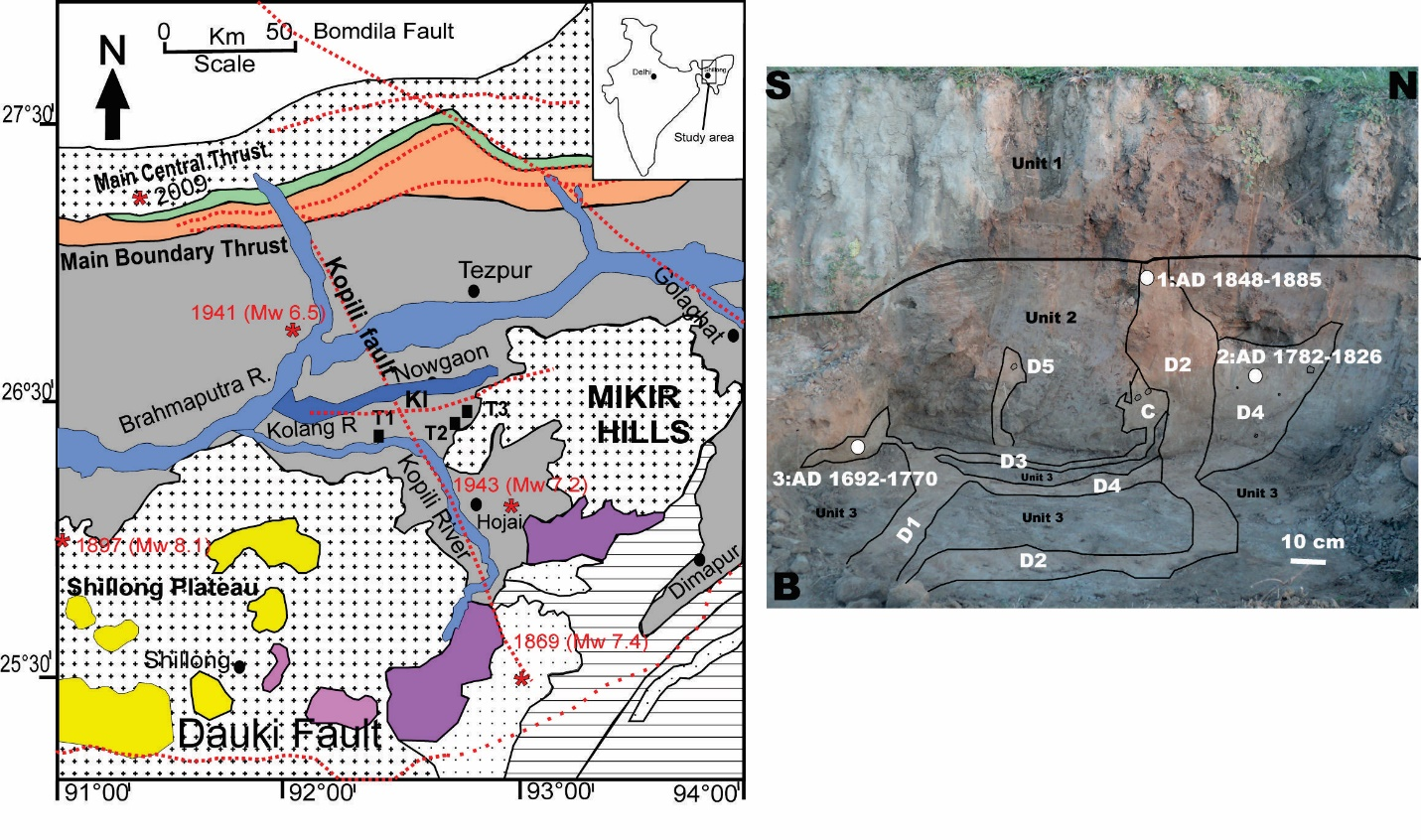
Figure 1: Geological location map of the study trench sites along Kolong River, KF, showing major structures (T1-Trench 1 at Namgaon site, T2-Trench 2 at Nampani site and T3- Trench 3 at Satargaon site). * denotes epicentres of earthquakes that occurred in the Kopili fault region are plotted on the map. Photograph showing observations from Namgaon Site, Trench 1, indicate two episodes of earthquake-induced liquefaction at Trench 1 since perhaps AD 1692.
")


")


