


Mishmi ranges (MR) in the North-Eastern tip of India, which has witnessed the imprints of the largest earthquake ever recorded in the Himalaya in the Kamlang Nagar town of Arunachal Pradesh, India has a widely distributed earthquake pattern, unlike the western and central Himalaya where the pattern is concentrated south of the Indus Suture Zone (ISZ, is the margin between the Eurasian and Indian Plates) over a nearly 30-km-wide at 10 - 20 Km depth. This implies that the earthquake nucleation or initiation in the MR is at deeper level, wider, and lies beyond the Tidding suture zone, which is equivalent of ISZ.
Earlier earthquake geologic study researches were confined only to the main Himalayan Frontal Thrust (HFT), without any considerable attempts in the Eastern flank of syntaxis. The Mishmi ranges, which preserve the imprints of the 1950 CE Tibet-Assam earthquake with a magnitude of around 8.6 Mw and more than 90 aftershocks which continued four months, remained neglected in this aspect.
A team of scientists working at the Wadia Institute of Himalayan Geology (WIHG), Dehradun, an autonomous institute of the Department of Science & Technology (DST), Govt. Of India recently carried out Earthquake geologic study of fault scarp or imprints of the 1950 Great Assam Earthquake. They found a dual surface faulting (movement of a fault deep within the earth breaking through to the surface) by the 1950 event along two fault systems --- the Himalayan Frontal Thrust and the Mishmi Thrust.
This shows that the seismicity pattern in the Mishmi Range where the locked zone of the Main Himalayan Thrust extends beyond the suture zone or (zone of joining together of separate terranes, tectonic units that have different plate tectonic histories) is unlike that of the western and central Himalaya. In the western and central Himalaya, the pattern or concentration of seismicity is dictated by the depth and location of brittle to ductile transition zone of deformation. However, in the Mishmi Range of eastern Himalaya underthrusting Indian plate is probably younger than the western and central Himalaya. The research has been published in the journal ‘Geophysical Research Letters’.
With the help of trench excavation, the WIHG team mapped the fault scarp at Kamlang Nagar in the field using a Real-Time Kinematic Global Positioning System (RTK-GPS). Seven radiocarbon samples were dated from the trench exposure to track the earthquake leading to the conclusion that the earthquake occurred at this site dated post-1761-1968 CE or in 1950. A dip-slip displacement of around 30 m was estimated, demonstrating the unique earthquake pattern of this region which was different from that in the western and central Himalaya.
Publication link: https://doi.org/10.1029/2020GL090893
For more details, contact Dr.Koushik Sen (koushik[at]wihg[dot]res[dot]in).
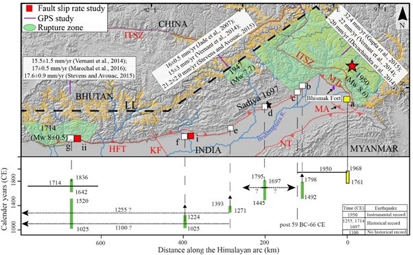
| Figure 1. Map of the eastern Himalaya between 90 and 97°E longitudes along the Himalayan front showing rupture zones of historical and instrumental earthquakes (after Bilham, 2019; light green polygons), location of previous trenches at g-Sarpang Chu, f-Nameri, e-Harmutty, d-Hemibasti, c-Marbang, b-Pasighat represented as white solid squares with present trench a-Kamlang Nagar shown as yellow solid square, and locations of fault slip rate studies of Burgess et al. (2012) and Berthet et al. (2014) at i-Nameri and ii-Sarpang shown as red squares. LL is the locking line at 3.5 km elevation contour. GPS convergence rates estimated for different segments of the eastern Himalaya are given in boxes. Spatiotemporal distribution of surface ruptures along the eastern Himalayan front given below correspond to the trenches a-f in the map given above. Horizontal solid lines denote the extent of earthquake ruptures and its uncertainty (dotted with arrowhead). Vertical green bars with arrow are probable extension of calibrated charcoal ages. Epicenter of 1697 Sadiya earthquake is shown as black star. Black arrows are the locations of Bhismak Fort (purple ellipse) and Manabhum Anticline (MA). |
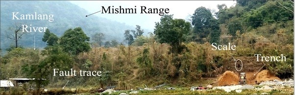
| Field photo showing trenched across the fault scarp at Kamalang Nagar, Wakro, in the Mishmi Range. |
")


")


