A new study of the Little Ice Age (LIA), a global climatic event, between CE 1671-1942, which shows significant variations of rainfall patterns during that age, challenges the conventional notion of a uniformly cold and dry climate with reduced monsoon rainfall during the LIA.
The Western Ghats experiences both the southwest summer monsoon (SWM) during June to September and the northeast winter monsoon (NEM) during October to December. Understanding the vegetation dynamics and corresponding hydro-climate variability from such an area, which was influenced by the both the SWM and NEM, could be crucial in understanding the monsoonal variability during the last millennium.
A study of pollen-based vegetation dynamics and contemporary climate change and monsoonal variability between CE 1219-1942 was reconstructed from the Western Ghats, India, by the Birbal Sahni Institute of Palaeosciences (BSIP), an autonomous institute of the Department of Science and Technology. It showed the record of moist (wet) LIA.
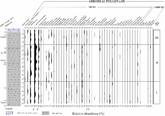
The scientists scouted core sediment samples from the Honnamanakere Lake in Karnataka and analysed pollen accumulated in them to reconstruct the vegetation-based climate change and monsoonal variability during CE 1219-1942 from the Western Ghats, India. Moist/semi-evergreen–dry tropical deciduous forests were mainly recorded from the study area.
Their study published in the journal Catena showed that record of the signature of moist conditions during Little Ice Age (LIA) from the Western Ghats, India, probably due to the increased NEM. The moist (wet) LIA, moreover, shows the hydro-climatic contrast.
They suggested that northward movement of the Inter Tropical Convergence Zone (ITCZ), positive temperature anomalies, increased sunspot numbers and high solar activity could be driving the climate change and increased SWM. They attributed the weakest phase of the ISM across the Indian subcontinent during the LIA, in general, to the southward shift of the ITCZ, resulting from increased northward energy flux across the equator, during a cold northern hemisphere.
The high-resolution palaeoclimatic records generated in the present study could be helpful in developing paleoclimatic models for future climatic predictions and also for a scientifically sound policy planning. Knowledge and understanding of the climate change and the Indian Summer Monsoon (ISM) variability during the Holocene could be of immense interest to strengthen the understanding of the present ISM-influenced climatic conditions, as well as of possible future climatic trends and projections.

Fig. 1. Shuttle radar topographic mission (SRTM) digital elevation map (DEM) of the Kodagu District, Bangalore (Karnataka State), Western Ghats, India, showing the location of the study area (the red star shows the study area) (d; lower panel, right one), geographic map of India showing Karnataka State (a; upper panel, left one); inset, right: geographic map of Karnataka State, showing the Kodagu District (b; upper panel, right one, with red star sign). This figure was created using ArcGIS 10.3. (c) Google Earth image showing the HKL sampling site (black dot in red circle) and core location in the centre of the Lake (lower panel; left one, white star sign) at the Kodagu District in Bengalore (Karnataka State), Western Ghats, India.

Fig. 2. Bayesian age-depth model of the HKL constructed using the R package rbacon (Blaauw and Christen, 2011). The blue bars indicate the AMS 14C age distribution, whereas the greyscale of the line graph reflects the likelihood; the dotted red line follows the mean ages.

Fig. 3. Pollen diagram showing the arboreal taxa (trees and shrubs) from the HKL sediment core, Western Ghats, India.

Fig. 4. Pollen diagram showing the non-arboreal taxa (herbaceous taxa including the terrestrial herbs, marshy taxa, aquatic taxa, as well as algal spores, pterydophytic taxa), drifted (transported) taxa, fungal spores and another non-pollen palynomorphs (NPPs) from the HKL sediment core, Western Ghats, India.


