


 Researchers from Wadia Institute of Himalayan Geology (WIHG), Dehradun an autonomous research institute under the Department of Science and Technology, Govt. of India have found an overall degenerating pattern in the glaciers of the Suru sub-basin (SSB) in Jammu and Kashmir in the Western Himalaya over the last 46 years with an enhanced rate after the year 2000.
The state of the Himalayan cryosphere (all-encompassing term for portions of Earth's surface where water is in solid form) has a bearing on multiple aspects of hydrology, climatology, environment, and sustenance of living organisms at large. Being sensitive indicators of climate change, any alteration in the glacier parameters would ultimately affect the associated hydrology of the major Himalayan Rivers. Thus comprehensive assessment of the Himalayan cryosphere together with suitable hydrological and climatological modelling is vital to ascertain the future viability of water resources.
Keeping this in mind, Dr. Aparna Shukla and her team of researchers from WIHG developed an inventory of the glaciers in SSB using multi-temporal satellite remote sensing data and limited field checks and analysed the observed glacier response in relation to the regional climate trends, local climate variability and other factors like regional hypsometry (measurement of land elevation relative to mean sea level), topographic characteristics, debris cover and geomorphic features). They found that the degeneration has taken place in the form of glacier shrinkage, retreat, debris accumulation, and rise in the snow line altitude (a proxy of mass balance). The study has been published in the journal Earth System Data Science.
Unlike eastern and central regions, glaciers in the western Himalaya reveal a larger scale of heterogeneity in their response owing to its vast latitudinal and longitudinal expanse. Despite this inherent heterogeneity in glacier response across the western Himalaya, complete and precise information on spatial coverage of glaciers is lacking, and existing inventories have disparate estimates requiring a continuous update.
The present study involved assessment of various dimensional parameters like area, length, debris cover, Snow Line Altitude(SLA), and topographic factors like slope, altitude range, and aspect of the glaciers and climatic conditions like temperature and precipitation prevailing in the sub-basin. For this, a set of optical satellite imageries ranging from medium (Landsat series sensors) to high (Linear Imaging Self-Scanning Sensor-IV) spatial resolution and Digital Elevation Model (DEM) Advanced Land Observing Satellite (ALOS) have been used by the researchers. Other than this, limited, yet repeated field investigations (on Pensilungpa and Kangriz glaciers) have been performed to validate the remote sensing estimations with the ground truth.
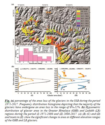
The study revealed that the majority of the glacierized basin area is occupied by small, clean ice glaciers having predominantly north orientation and spread in two major ranges of Himalaya -- the Greater Himalayan (GHR) and the Ladakh (LR) Ranges.
The study also confirms the transitional response of the SSB glaciers between the Karakoram and the GHR glaciers. Long time series climate data (1901-2017) shows an increase in the mean annual temperature (particularly minimum temperature), driving the overall glacier variability in the region. Glaciers in the sub-basin experienced local climate variability, with the GHR glaciers exhibiting a warmer and wetter climate as compared to the LR glaciers. This local climate variability, along with the unique topography induced heterogeneity in glacier response, evident in the GHR and LR glaciers. While the GHR glaciers exhibit an overall rise in SLA and accelerated retreat rates, the LR glaciers have deglaciated more, with an enhanced accumulation of debris cover.
")


")


