


The strength of the Indian Summer monsoon has declined over high altitude regions in the Kumaon-Garhwal Himalaya (KGH), said a new study of oxygen isotopes of tree rings in this region collected over 508 years (1508-2015 CE). Such records can accurately define the nature and strength of the upcoming droughts through proper modelling and drought assessment and help planning and development in drought prone regions.
The recurring droughts across the various flood plains in India have been known before our Independence era. These droughts have largely impacted our agrarian population and influenced agricultural practices. The effects of these great droughts have been large scale both spatially and temporarily. The instrumental climate records from Himalaya are very limited in both spatial and temporal scale. To understand the long-term climatic variability, long climatic records from this region are required. This could be achieved through analyses of proxy records.
Tree-ring is one of the proxy records to acquire annual resolution climate data at an annual, decadal to centennial scale. Asia has a large network of tree-ring based proxy records of past climatic variations and other environmental phenomenon. India has also good number of tree-ring records across the Himalaya and tropical regions of multiple tree-taxa. Thus various researchers have established dendrochronological potential of Indian trees and various forest types.
Birbal Sahni Institute of Palaeosciences (BSIP), Lucknow with a well-established Dendrochronology Laboratory has large numbers of tree-ring datasets from India and acquired several tree-ring isotope records from the Asian subcontinent through different databases. These datasets can provide information regarding regional and large scale hydroclimatic variability. Following standard procedure and protocols, isotope data from each tree-ring of core samples were generated and further analysed. Based on regional tree-ring stable oxygen isotope record and the resultant dataset, Scientists from the institute have traced the longest summer drought variability for Kumaon-Garhwal Himalaya region.
This isotope records covering Kumaon-Garhwal Himalaya captured the spatio-temporal distribution of drought and pluvial conditions prevailing in India and the response to the various known feedback mechanisms. The mechanisms such as El Niño southern Oscillation (ENSO) and regional SST patterns have their exogenous influence on the region through their influence on atmospheric circulation causing the variability in the climate scenario as observed in the present study. The multi-century summer drought reconstruction highlighted the variation in strength of the Indian summer monsoon.
The reconstructed summer drought variability based on regional δ18OTR record showed an increasing intensity and frequency of summer monsoon drought over the past 508 years (1508-2015 CE) in the Kumaon-Garhwal Himalaya. This drought reconstruction published in the journal Quaternary Science Review indicates that there is a pattern in the strength of the past drought (late 16th to early 17th century) and the recent drying trends (late 20th to early 21st century) could possible lead to more extreme droughts in the future as observed in the past. The δ18OTR regional record of Kumaon-Garhwal Himalaya is linked to oceanic phenomenon such as sea surface temperature (SST) in the Pacific and Indian Ocean.
For the study, the set of accurately cross-dated tree core samples, two oldest cores (one from each sampling site i.e., Dhola and Harshil, Uttarkashi, Uttarakhand) were selected and cellulose was extracted for 908 rings and later isotopic measurements were carried out. These isotopic time series datasets were combined with already available δ18OTR record from adjoining region. Thus, a 508-year regional tree-ring stable oxygen isotope (δ18OTR) record for multiple coniferous taxa (Abies spectabilis, Cedrus deodara and Picea smithiana) for the KGH, which spanned 1508-2015 CE was developed and analysed further to reconstruct drought beyond the existing instrumental datasets. The present record increases the length of the past drought known through the tree-ring based isotope record.
The study can help us understand the intensity of these droughts in the past and compare with our present drought records through high resolution data such as tree-rings. Once we understand these patterns of drought and their intensity we can model the future drought and their probable impact throughout the agricultural plains and high altitude regions of India.
Publication link: https://doi.org/10.1016/j.quascirev.2022.107927
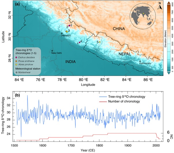
(a) Map showing sites of tree-ring stable oxygen isotope (δ18OTR) records and location of the meteorological station. The number denotes each sampling site and their details are given in Table S1. (b) Regional δ18OTR record from Kumaun-Gharwal Himalaya, which extends from 1508-2015 CE and developed using six δ18OTR series.
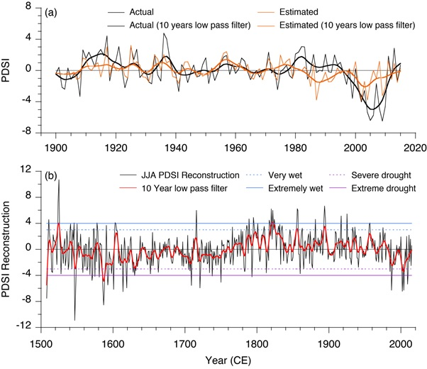
(a) The actual and estimated JJAPDSI for calibration period of 1901-2015 CE (b) JJAPDSI reconstruction with 10-year low-pass filter for Kumaun-Gharwal Himalaya. The horizontal black solid line indicate the mean of the JJAPDSI reconstruction. The blue solid and dashed line are PDSI value for extreme wet (+4.0) and very wet (+3.0) respectively. The purple solid and dashed line are PDSI value for extreme drought (−4.0) and severe drought (−3.0) respectively.
")


")


