It was the Westerlies, or the permanent winds that blow from the subtropical high-pressure belts towards sub-polar low-pressure belts, and not the Indian Summer Monsoon (ISM), that governed the climatic variations and the evolution of its landscape, particularly during the Mid-Holocene Thermal Maxima (between 7075 and 6040 cal yr before present), according to a new study.
This is evident from the analysis of a huge detrital influx recorded at the lake bottom, indicating a glacial advancement in the region, particularly during the Mid-Holocene Thermal Maxima. Researchers found that the Westerlies and the ISM have had periodic shifts in defining the climatic variations of the NW Trans Himalaya. The affect of the Mid-Holocene warm period is evident at 6040 cal yr Before Present (BP), with the advent of ISM, and paradigm shifts are observed at 5710, 4890, 3435, and 2800 cal yr BP. The influence of westerlies gradually reduces at 2800 cal yr BP.
The Himalaya is the most glaciated mountain regions on Earth outside poles and lies between the Indian Summer Monsoons and mid-latitude westerlies troughs. Glaciation in this region responds sensitively to changes in global climate, providing a proxy to quantifying regional and global climate change. Furthermore, glacial fluctuations in the Himalaya significantly affect the hydrological balance of Himalayan Rivers and monsoon variability. Several glacial lakes are seen in the Ladakh Range, triggering hypothesis that these lakes could give an authentic picture of the entire region. Moreover, these lakes present at an altitude of 5000 m, far from the anthropogenic impact, and are an important archive to study the limnological characteristics and climatic variations. Although several glacial lakes have been seen in the area, the high altitudes, low oxygen levels, and hard terrain have been challenging for researchers to study.
A team from Birbal Sahni Institute of Palaeosciences (BSIP), an autonomous institute of the Department of Science and Technology (DST), collected sediments from the lakes and used them as archives to carry out a high-resolution multi-proxy climatic record from Ladakh-the cold desert of India lying above the altitudes of 3000m in the Trans-Himalaya.
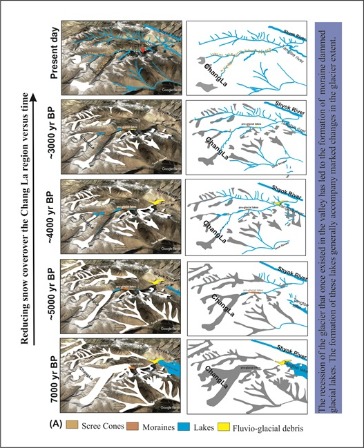
Their research published in the journal Catena is a detailed case study of the changing scenario in the region since the last seven thousand years. It brings about a picture of the retreating glaciers from the Chang La based on sub-century to centennial proxy climatic records chronology and the distribution of landforms (moraine and pro-glacial lakes).
This detailed case study of the changing scenario in the region since the last seven thousand years analyses the relationship of the lake levels to the precipitation regimes (ISM and westerlies) active in the area, and the detailed landscape evolution of the largest basin of the Ladakh Range namely- Chang La-Tangtse basin for the first time.
The research will help characterize and assess the past climatic changes for a better assessment of regional and global forcing factors of future glacier behaviour in the context of global warming, climate variability, and associated societal impacts.
Publication link: https://doi.org/10.1016/j.catena.2022.106907

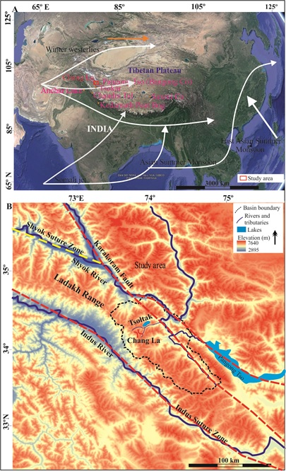
A. Google Earth image showing the Himalayan region and the Third pole B. DEM
imagery depicting the study area.

Schematic representation of the retreating glacier and lake formation during last 7000 yrs in
The Chang La-Tangtse basin based on palaeoclimatic record and field observations.

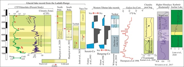
Comparative sketch of the CTP magnetic susceptibility (χlf) and δ 13 C values of organic
carbon compared with other glacial lake records of the Ladakh range Joshi et al.,
2021, Phartiyal et al., 2020; 2021); western Tibetan lake records ( Gasse et al., 1996; Fontes et
al., 1996; Thompson et al., 1996; Wünnemann et al., 2010 ) and higher Himalayan records
( Kumar et al., 2020 , Lone et al., 2020 , Srivastava et al., 2017 ).


